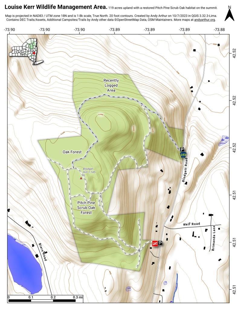
Louise E. Keir Wildlife Management Area
Download a High Resolution JPEG Image of the Louise E. Keir Wildlife Management Area or an Adobe Acrobat Printable PDF of the Louise E. Keir Wildlife Management Area.


Bookmark my free Interactive GPS Map for your phone:
https://andyarthur.org/ny
... shows your location as a blue dot in relationship to campsites, trails, state land. This online map requires cell service, won't work in remote country, so also bring a paper map.
Free Download of New & Historical USGS 1:24k Topograpic Maps
Interactive maps with backcountry and roadside camping: New York, Pennsylvania, West Virginia & Vermont. List of NYS DEC Lean-Tos and Firetowers.
Google Spreadsheet with Roadside, Primitive and Pay Campsites
More about Louise Kerr Wildlife Management Area...
119 acres, upland, parking lot, birdwatching, snowshoeing, hunting and trapping. This WMA is located in the Town of Coeymans. To reach the area from Coeymans Hollow, take County Route 103, north 3 miles to state land.
http://www.dec.ny.gov/outdoor/8297.html


![Photo: Untitled [Expires August 2 2026]](/data/photo_25427_small.jpg "Photo: Untitled [Expires August 2 2026]")
![Photo: Pitch Pines! [Expires August 2 2026]](/data/photo_25404_small.jpg "Photo: Pitch Pines! [Expires August 2 2026]")
![Photo: Untitled [Expires August 2 2026]](/data/photo_25432_small.jpg "Photo: Untitled [Expires August 2 2026]")


![Photo: Untitled [Expires August 2 2026]](/data/photo_25485_small.jpg "Photo: Untitled [Expires August 2 2026]")


