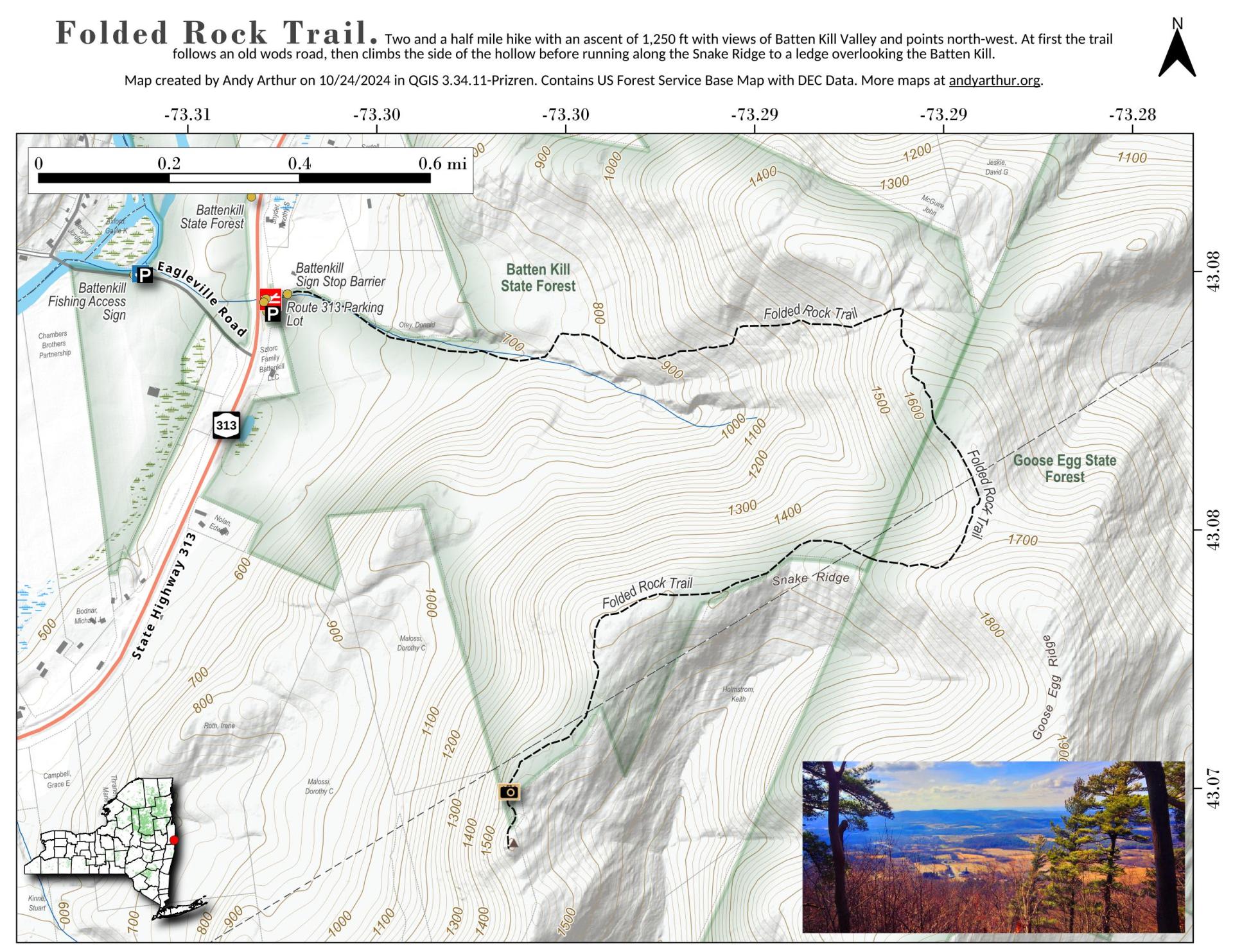
Folded Rock Trail

Download a High Resolution JPEG Image of the Folded Rock Trail or an Adobe Acrobat Printable PDF of the Folded Rock Trail.


Bookmark my free Interactive GPS Map for your phone:
https://andyarthur.org/ny
... shows your location as a blue dot in relationship to campsites, trails, state land. This online map requires cell service, won't work in remote country, so also bring a paper map.
Free Download of New & Historical USGS 1:24k Topograpic Maps
Interactive maps with backcountry and roadside camping: New York, Pennsylvania, West Virginia & Vermont. List of NYS DEC Lean-Tos and Firetowers.
Google Spreadsheet with Roadside, Primitive and Pay Campsites
More about Batten Kill State Forest...
The Battenkill State Forest and Goose Egg State Forest are back to back and take up 983 acres combined. There is a small, grassy parking area on RT 313, just east of Eagleville Rd. The Folding Rock trail goes through the Battenkill State Forest, crosses briefly into the Goose Egg State Forest and then back where it ends at the southern edge. Round trip is a little over 5 miles and there is an ascent of 1260 feet.
http://www.amcmohawkhudson.org/outdoors/view.asp?loc=bksf


No Comments
I was hoping to hike this trail. I got to the parking lot near the creek but saw no indication of a trail. I asked a few people, but they knew nothing . I went to a store in Vermont but they had no info. I took a short walk along the river. The foliage was beautiful, but it was disappointing I could not find the hike.
Sorry to hear that. I’ve not done the trail but it does look nice, especially in the autumn.
http://walkingman247.blogspot.com/2018/09/folded-rockbattenkill-state-forest.html
Maybe this will be helpful.
https://www.alltrails.com/explore/recording/battenkill-state-forest
And this site too.
https://heathercoton.wordpress.com/2012/01/02/folded-rock-trailhead/#jp-carousel-3964
This really has me interested in doing this hike, it looks nice.