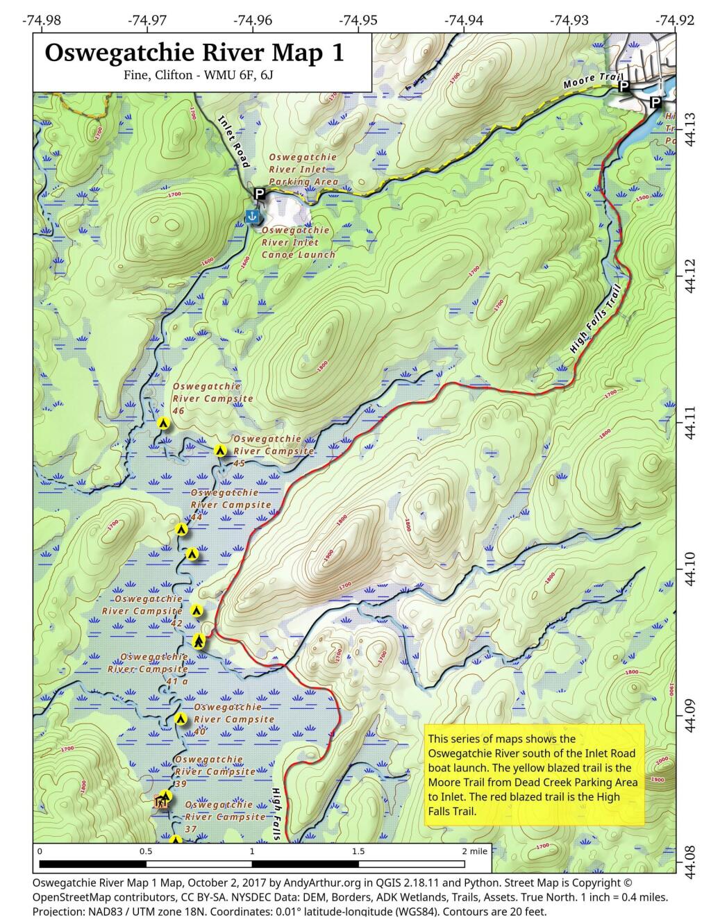
Printable Maps of Oswegatchie River Campsites and Lean-Tos
List of Oswegatchie River Campsites and Lean-Tos
Here is a list of Oswegatchie River Campsites and Lean-Tos with coordinates. They are sorted north to south. You can also get this as a Google Sheet for ease of downloading into your GPS.
Name
Details
Location
Oswegatchie River Inlet Parking Area
Gravel parking area
44.12443118931201,-74.96021183665184
Oswegatchie River Inlet Canoe Launch
Hand carry launch. Oswegatchie river
44.12409861000839,-74.96006625629072
Oswegatchie River Campsite 46
Designated campsite. No outhouse.
44.1099997656786,-74.96849666115645
Oswegatchie River Campsite 45
Designated campsite. No outhouse. Large White Pine overstory.
44.1081261918206,-74.9631088853723
Oswegatchie River Campsite 44
Designated campsite. No outhouse. White Pine overstory.
44.10274849797629,-74.96679915443202
Oswegatchie River Campsite 43
Designated campsite. No outhouse. Nice site under White Pine and hemlock.
44.101065191632905,-74.96577985008783
Oswegatchie River Campsite 42
Designated campsite. No outhouse.
44.09720754685212,-74.96536327814668
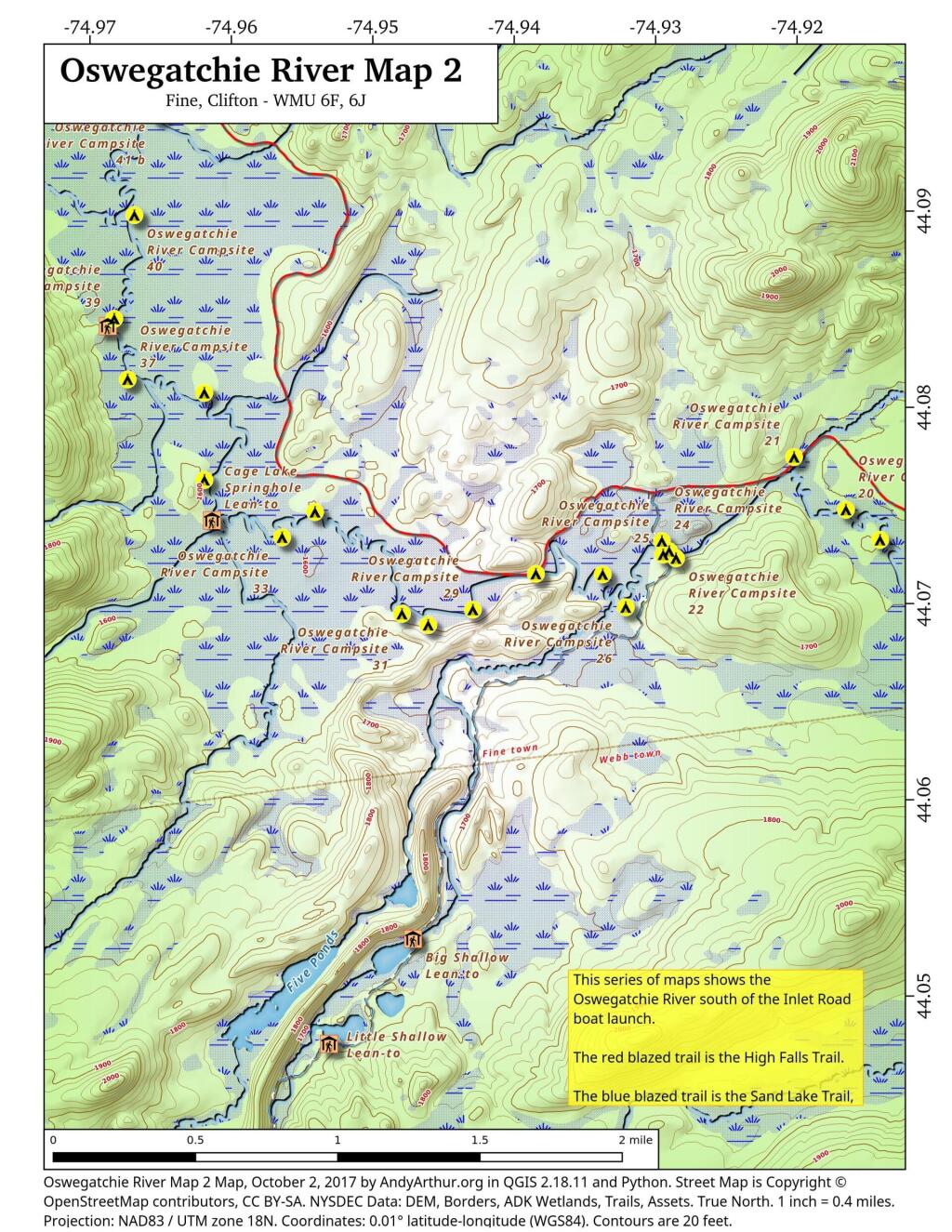
Oswegatchie River Campsite 41 B
Designated campsite. Shares full sized outhouse with 41 a.
44.0952454709372,-74.96512556000707
Oswegatchie River Campsite 41 A
Designated campsite. Shares full sized outhouse with 41 b.
44.09498215224536,-74.96519748460433
Oswegatchie River Campsite 40
Designated campsite. No outhouse.
44.08981881642045,-74.96686858363239
Oswegatchie River Campsite 39
Designated campsite. Shares full sized outhouse with lean-to.
44.0845390569362,-74.96829359032023
Griffin Rapids Lean-To
Oswegatchie river campsite 38. With full sized outhouse.
44.08416539190812,-74.96874797335943
Oswegatchie River Campsite 37
Designated campsite. No outhouse.
44.081449235808094,-74.96734861635957
Oswegatchie River Campsite 36
Appears to be rarely used. Re-signed at campsite, 05/2016.
44.08076066223312,-74.96192854447926
Oswegatchie River Campsite 21
With full sized outhouse. outhouse needs to be replaced.
44.0774668251364,-74.92023479225502
Oswegatchie River Campsite 35
Poor campsite on narrow bank along river. No outhouse.
44.07631976413254,-74.96192259334101
Oswegatchie River Campsite 20
Designated campsite. No outhouse.
44.07477874950931,-74.91657391326872
Oswegatchie River Campsite 32
Designated site. No outhouse.
44.07468487279131,-74.95410705888409
Cage Lake Springhole Lean-To
Oswegatchie River Campsite 34 and Buck Brook lean-to. With full sized outhouse.
44.07426192277586,-74.96138724158183
Oswegatchie River Campsite 33
Designated campsite. No outhouse.
44.073391797670325,-74.95643228093942
Oswegatchie River Campsite 19
Designated campsite. No outhouse.
44.07324092124128,-74.9141633627036
Oswegatchie River Campsite 24
Campsite on knob just north of foot bridge.
44.073192307051784,-74.92958639526513
Oswegatchie River Campsite 23
No obvious outhouse.
44.07267707183023,-74.92907367419755
Oswegatchie River Campsite 25
Designated campsite. No obvious outhouse
44.07250675167277,-74.92949519999124
Oswegatchie River Campsite 22
No obvious outhouse.
44.07231405159984,-74.92858911655944
Oswegatchie River Campsite 28
No obvious outhouse. On narrow strip of land between river and hiking trail.
44.07152841600008,-74.9384951811928
Oswegatchie River Campsite 27
Designated site. No outhouse.
44.071498659692026,-74.93377315442581
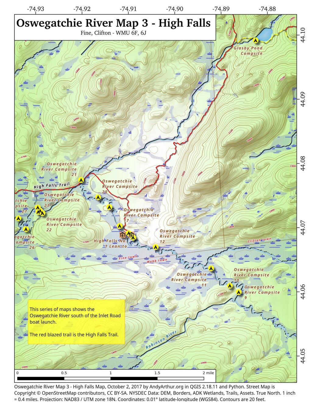
Oswegatchie River Campsite 17
No obvious outhouse.
44.07030826156362,-74.9119367954832
Oswegatchie River Campsite 26
Designated site. No outhouse. Former site of guide art leary’s camp.
44.06982014142839,-74.93214452928088
Oswegatchie River Campsite 29
Designated campsite. No outhouse.
44.069703084074106,-74.94295216734594
Oswegatchie River Campsite 31
Designated site. No outhouse.
44.06949136260463,-74.94796488517912
Oswegatchie River Campsite 16
With full sized outhouse.
44.06919421410159,-74.90997016838134
Oswegatchie River Campsite 30
Designated campsite. No outhouse.
44.06892407580466,-74.94610904969508
High Falls No. 2 Lean-To
Also here, Oswegatchie river campsite 13. With full sized outhouse.
44.06891348697742,-74.9113129664397
High Falls No. 1 Lean-To
Also here, Oswegatchie river campsite 15. With full sized outhouse.
I’ve been following your maps for years, often use them as resources for my trips. Wondering if you had any thoughts on a trail or portage that would link Stillwater Reservoir to the upper Oswegatchie so I take a new it down stream from its highest point down into Inlet? There seems to be a possibility of canoeing up Alder Creek and possibly a trail, but can’t see anything to verify that this is a doable route. I’ve done the Low’s Lake traverse, looking for something different and challenging.
4 Comments
I’ve been following your maps for years, often use them as resources for my trips. Wondering if you had any thoughts on a trail or portage that would link Stillwater Reservoir to the upper Oswegatchie so I take a new it down stream from its highest point down into Inlet? There seems to be a possibility of canoeing up Alder Creek and possibly a trail, but can’t see anything to verify that this is a doable route. I’ve done the Low’s Lake traverse, looking for something different and challenging.
That I don’t know, it’s not been a part of the Adirondacks I’ve explored much.
The Red Horse Trail leads north from Stillwater Reservoir about 1/3 of the way to the Oswegatchie. After that it seems to be a bushwack.
A google search will turn up trip reports of Stillwater to Oswegatchie treks. For example:
http://bushwhackingfool.com/2010/07/21/stillwater-reservoir-to-cranberry-lake-trip-day-one/
Probably a packraft would be the best craft for such a trip.
Is there a map 4? a map that shows past campsite 9 and beyond?
Any thoughts on being able to paddle/portage from the upper oswegatchie (near campsite 4) to Moose Bay on Lows Lake?