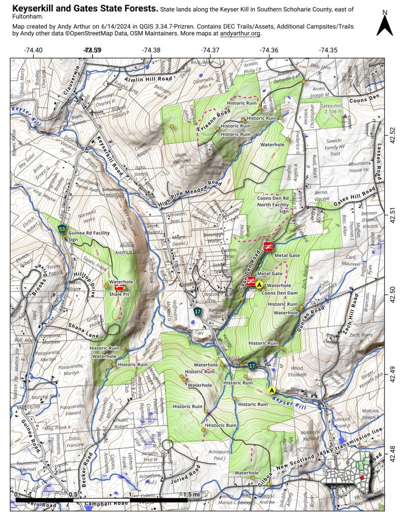
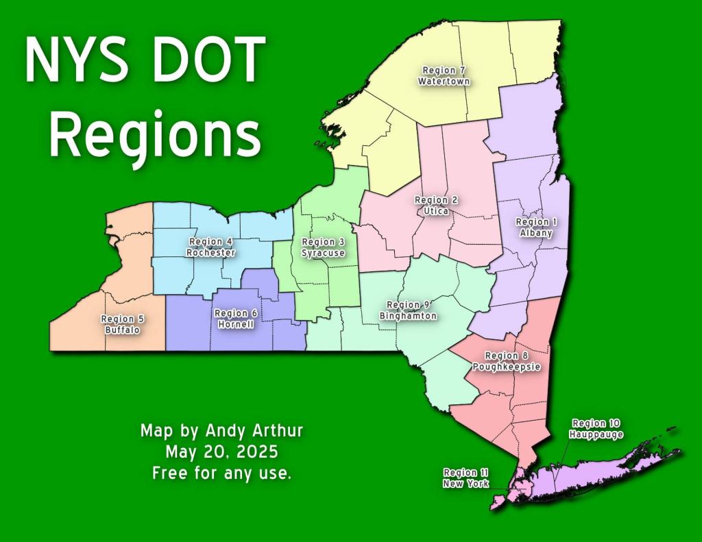
Thematic Map: NYS DOT Regions Download a High Resolution JPEG Image of the NYS DOT Regions or an Adobe Acrobat Printable PDF of the Thematic NYS DOT Regions. About NYS DOT Regions .... A map of the various NYS Department of Transportation Regions. More about Transportation...Aerial PhotosSOOKE HISTORY: Bedspring Bridge was unforgettable experience | Sooke News MirrorThe Eagle Lake & West Branch Railroad: Discover History & Explore Nature: State Parks and Public Lands: Maine ACFMaps and InteractivesUS Roads and Railroads, Rand McNally 1918Traffic Light 🚦 Caution ⚠ FlashersThe Eagle Lake and West Branch RailroadStudebakerSouthern Albany County – Bridge InventoryRailroad Mileage Map 1910 – Rand McNally and CompanyNY 8 and 12 Intersection at Interstate 790 and the ThruwayLocation of the Palatine Ohio Trail DerailmentLarge junkyard south of ScrantonHow Fast Can I Drive on State Highways in Capital Region ?Hartford Ghost RampsCovered Bridges in New York StateCenter Square Neighborhood of Albany vs Thruway-Northway Interchange (Size Comparison)NYS Bridges with Weight LimitsCapital Region Bridges with Weight LimitsBridges Rated Below 3.5 in Capital RegionBefore and After Rennselear Train Station1915 Canakkale BridgeUS 9 SuffixesUnpaved Roads in New York StateTraffic Volume on NYS HighwaysTime to Cycle to from Delaware and CherrySpeed Limit on Interstates and State Touring Routes in Capital RegionRailroad Mileage Map 1910 – Rand McNally and CompanyProposed and Under Construction Capital Region Highways, 1969... photos, maps and other content from from Transportation. Leave a Reply Cancel replyYour email address will not be published. Required fields are marked *Comment * Name * Email * Website Save my name, email, and website in this browser for the next time I comment. Δ
More about Transportation...Aerial PhotosSOOKE HISTORY: Bedspring Bridge was unforgettable experience | Sooke News MirrorThe Eagle Lake & West Branch Railroad: Discover History & Explore Nature: State Parks and Public Lands: Maine ACFMaps and InteractivesUS Roads and Railroads, Rand McNally 1918Traffic Light 🚦 Caution ⚠ FlashersThe Eagle Lake and West Branch RailroadStudebakerSouthern Albany County – Bridge InventoryRailroad Mileage Map 1910 – Rand McNally and CompanyNY 8 and 12 Intersection at Interstate 790 and the ThruwayLocation of the Palatine Ohio Trail DerailmentLarge junkyard south of ScrantonHow Fast Can I Drive on State Highways in Capital Region ?Hartford Ghost RampsCovered Bridges in New York StateCenter Square Neighborhood of Albany vs Thruway-Northway Interchange (Size Comparison)NYS Bridges with Weight LimitsCapital Region Bridges with Weight LimitsBridges Rated Below 3.5 in Capital RegionBefore and After Rennselear Train Station1915 Canakkale BridgeUS 9 SuffixesUnpaved Roads in New York StateTraffic Volume on NYS HighwaysTime to Cycle to from Delaware and CherrySpeed Limit on Interstates and State Touring Routes in Capital RegionRailroad Mileage Map 1910 – Rand McNally and CompanyProposed and Under Construction Capital Region Highways, 1969... photos, maps and other content from from Transportation.
Leave a Reply Cancel replyYour email address will not be published. Required fields are marked *Comment * Name * Email * Website Save my name, email, and website in this browser for the next time I comment. Δ